
State of emergency issued in Southern California due to storm
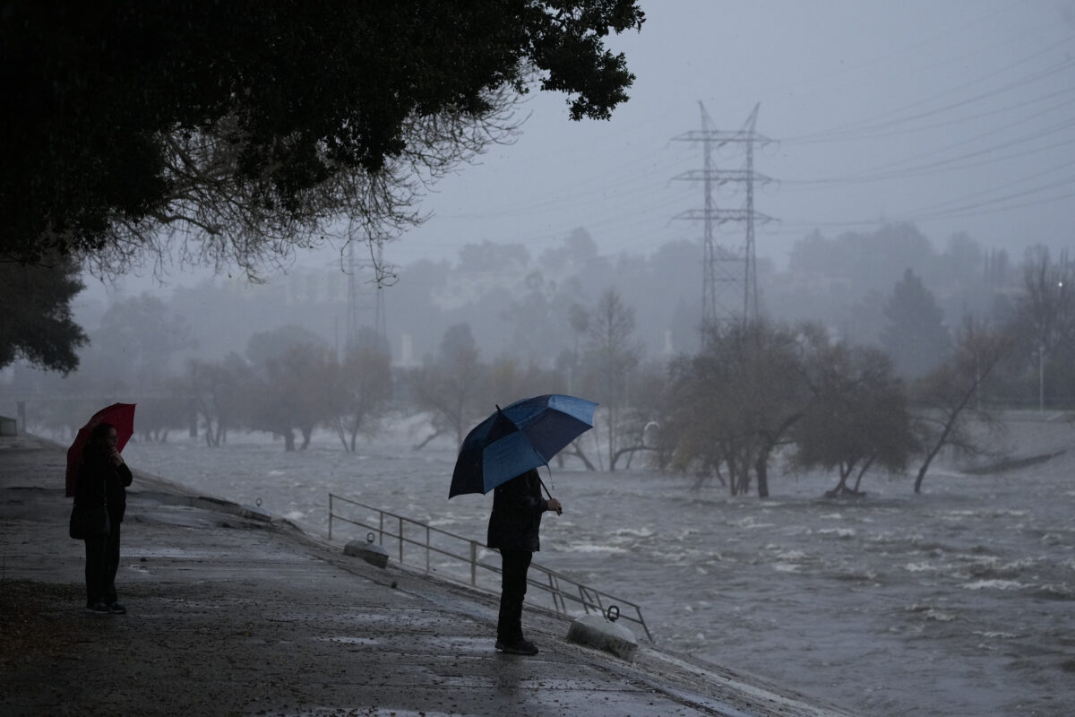
A couple walks on the edge of the Los Angeles River, carrying stormwater downstream Sunday, Feb. 4, 2024, in Los Angeles. The second of back-to-back atmospheric rivers battered California, flooding roadways and knocking out power to hundreds of thousands and prompting a rare warning for hurricane-force winds as the state braced for what could be days of heavy rains. (AP Photo/Damian Dovarganes)
LOS ANGELES – Evacuation orders were issued in parts of Los Angeles County today as a powerful storm landed in the Southland, bringing “life-threatening” flood risks and dangerously high winds to the area.
Los Angeles officials urged residents to stay home and off the roads Sunday and Monday, and Gov. Gavin Newsom declared a state of emergency in eight counties in the state, including Los Angeles and Orange counties.
The County of Los Angeles later declared its own state of emergency.
“Los Angeles County is taking action to protect our communities during the storm and to recover from any impacts that may result,” said Los Angeles County Board of Supervisors Chair Lindsey P. Horvath. “This emergency declaration allows us to move quickly to deploy resources, and it aligns with Governor Newsom’s order issued today. The state, county and the 88 cities of Los Angeles County are working together to keep everyone informed, prepared and safe. Thank you for staying inside and off the roads.”
The emergency proclamation will help expedite procurement of vital supplies and resources, deployment of disaster service workers and the use of emergency protective measures such as evacuation orders.
On Sunday evening, the California State University system announced some local campuses would be closed on Monday. Cal State Los Angeles, Cal State Northridge, Cal State Long Beach and Cal State Fullerton will be holding classes remotely on Monday.
Residents in the La Tuna Canyon Road area north of Hollywood Burbank Airport were ordered to evacuate until Tuesday due to the high risk of debris flow triggered by the heavy rain.
The affected area borders Horse Haven Street to the north, Martindale Avenue to the east, Penrose Street to the south, and Ledge Avenue to the west, according to the Los Angeles Fire Department.
Evacuation centers for people and household pets have opened at Sunland Senior Citizen Center at 8640 Fenwick St. and Lake View Terrace Recreation Center at 11075 Foothill Blvd. Large animals can be evacuated to Hansen Dam Horse Park at 11127 Orcas Ave. in Lake View Terrace, and the LA Equestrian Center at 480 Riverside Drive in Burbank.
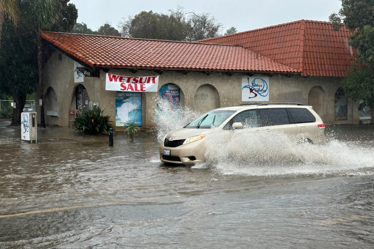
A vehicle drives through water on a flooded street in Ventura, Calif., Sunday, Feb. 4, 2024. Southern California was at risk of substantial flooding beginning late Sunday because of how slow the system was moving, said Ryan Kittell, a meteorologist at the weather service’s Los Angeles-area office. (AP Photo/Eugene Garcia)
“Debris flows can bring water, mud, boulders, and other debris that can cover cars and houses. Pack all people and pets into your vehicle and leave the area immediately,” the LAFD said.
Earlier evacuation orders were issued for the Owen Fire area, on Santa Maria Road from Topanga Canyon, and the Agua Fire area along Soledad Canyon Road east of Agua Dulce Canyon Road.
Those orders are in effect from 6 p.m. Saturday through 6 p.m. Tuesday.
Additionally, evacuation warnings have been issued for areas of unincorporated Los Angeles County near burn scars from 10 a.m. Sunday through 6 p.m. Tuesday, including the Juniper Hills and Valyermo areas from the Bobcat Fire, and the following areas of Lake Hughes and King Canyon from the Lake Fire: — 20000 block of Pine Canyon Road; — 18000 block of Ellstree Drive; — 46000 block of Kings Canyon Road; — 18000 block of Newvale Drive; — 43000 block of Lake Hughes Road.
The city of Duarte also used an evacuation warning for an area in the Fish Fire burn scar. That warning is in effect from 6 p.m. Sunday through 10 a.m. Tuesday for the area on Mel Canyon Road between Fish Canyon Road and Brookridge Road.
Residents can check lafd.org/alerts for updates.
The multiple-day storm could drop 4 to 8 inches of rain in coastal and valley areas, and 8 to 14 inches in the mountains and foothills, with much of that downpour occurring in a 24- to 36-hour period between Sunday into Monday, according to the National Weather Service.
Mountain road closures were anticipated, with possible closure of the Grapevine on Tuesday, and avalanche potential above 7,000 feet, the NWS said.
A flood watch will be in effect from Sunday afternoon through Tuesday afternoon for Los Angeles County.
“This is a DANGEROUS SYSTEM with major risks to life and property,” the NWS’ Los Angeles office said early Sunday afternoon. “Substantial flooding. Residents should heed any evacuation orders. Stay off the roads, especially the freeways, this afternoon through at least Monday morning.”
Newsom’s emergency proclamation includes provisions authorizing a California National Guard response if tasked, facilitating unemployment benefits for impacted residents, and making it easier for out-of-state contractors and utilities to repair storm damage.
The other counties included were Riverside, San Bernardino, San Diego, San Luis Obispo, Santa Barbara and Ventura counties.
The weather service said earlier that “given the sheer amounts of rainfall expected in the time period, the 3-6 hour rain rates could be problematic, exceeding USGS thresholds which could lead to mud/debris flow issues as well as swift water rescues in the local rivers and streams,” the NWS said.
“The Los Angeles River will fill quickly and become a raging river and a very dangerous place to be,” the NWS said earlier. “Anyone in that basin should be removed well before the onset of rain. Creeks and streams may rise out of their banks. Flooding may occur in poor draining and urban areas.
Low-water crossings may be flooded. Storm drains and ditches may become clogged with debris. Extensive street flooding and flooding of creeks and rivers are possible.”
The weather service also predicted a threat of thunderstorms to most areas Sunday through Monday, with the threat lingering over Los Angeles County through Tuesday. Forecasters also cited a threat of waterspouts over coastal waters and even small tornadoes over land.
The city of Torrance issued a flood warning to residents on Sunday evening, cautioning that debris flows were imminent or occurring. Residents were urged to take immediate precaution to protect life and property, and avoid nonessential travel.
The heavy rain will be accompanied by strong winds in many areas, blowing at speeds of 30 to 50 mph in parts of LA County, and reaching up to 60 to 80 mph in higher mountain areas and the Golden State (5) Freeway corridor.
A high wind warning was in effect until 6 a.m. Monday for most of Los Angeles County.
A winter storm watch will be in effect in the eastern San Gabriel Mountains through Tuesday afternoon, with forecasters predicting as much as 2 to 4 feet of snow above 7,000 feet, as much as 20 inches as low as 6,000 feet, and 8 inches at 5,000 feet. Winds will also gust in that area at 80 mph.
Officials said downed trees and power lines and power outages were also strong possibilities.
A high surf advisory was issued from 10 p.m. Sunday to 10 p.m. Monday at Orange County beaches, and until 9 p.m. Monday at Los Angeles County beaches.
Los Angeles Mayor Karen Bass urged Angelenos to stay home Sunday and Monday, and said the city has taken a range of preemptive measures, including placing the city’s Emergency Operations Center at Level 2.
“The city has been working urgently in anticipation of the storm that’s expected to hit us Sunday, Monday and possibly Tuesday,” Bass said Friday afternoon. “We know that weather predictions can change quickly, but right now there are indications that the coming storm could be as strong as Tropical Storm Hilary was in August.”
Bass and other top city and county officials reiterated that message at a Sunday afternoon news conference, urging the public to stay off roads and to obey all evacuation orders.
Los Angeles Unified School District Superintendent Alberto Carvalho said the district planned to keep schools open Monday, with the exception of Vinedale Elementary School in Sun Valley. Carvalho added that district officials would continue to monitor the storm, and plans could change later Sunday night.
The city and the Los Angeles Homeless Services Authority increased shelter and housing voucher availability to accommodate an influx of homeless people coming in from the storm. Extra shelters were expected to be open by Sunday.
Residents can call 2-1-1 for transportation to a shelter.
The coming storm was also affecting the recreational activities available to Southern California residents this weekend. NASCAR bumped up its scheduled Sunday doubleheader at the Coliseum, including the Busch Light Clash, to Saturday night. Six Flags Magic Mountain was closed Sunday and Monday. Santa Anita Park canceled Sunday’s eight-race program due to the forecast. And the Getty Center and Villa announced it would be closed Sunday and Monday.
The wet weather pattern will continue into Tuesday evening, with periods of rain anticipated to continue. Drier conditions are expected by Wednesday, but a chance of showers will still linger. Snow levels could fall as low as 3,500 feet by Thursday, forecasters said. (CNS)
