
Powerful storm headed to SoCal, bringing ‘life-threatening’ flooding
LOS ANGELES – A major storm, spanning multiple days beginning Sunday, is expected to create “life-threatening” flood risks throughout the Los Angeles area, forecasters said yesterday.
“People need to start preparing now for a major flooding event,” National Weather Service forecasters warned.
The multiple-day storm could drop 3 to 6 inches of rain in coastal and valley areas, and 6 to 12 inches in the mountains, with much of that downpour occurring in a 24- to 36-hour period between Sunday into Monday, the NWS said.
“Historically, rainfall of this magnitude creates major hydrologic problems in our area and there’s no reason to think this won’t happen with this event,” forecasters said.
The heavy rain will be accompanied by strong winds in many areas, blowing at speeds of 30 to 50 mph in parts of LA County, and reaching up to 60 to 80 mph in higher mountain areas and the Golden State (5) Freeway corridor.
Waves crash into the windows of the Marine Room restaurant during a storm Tuesday, Jan. 23, 2024, in La Jolla, Calif. (AP Photo/Denis Poroy)
A flood watch was in effect from Sunday afternoon through Tuesday afternoon for Los Angeles County.
“Given the sheer amounts of rainfall expected in the time period, the 3-6 hour rain rates could be problematic, exceeding USGS thresholds which could lead to mud/debris flow issues as well as swift water rescues in the local rivers and streams,” the NWS said.
“The Los Angeles River will fill quickly and become a raging river and a very dangerous place to be,” the NWS said earlier. “Anyone in that basin should be removed well before the onset of rain. Creeks and streams may rise out of their banks. Flooding may occur in poor draining and urban areas.
Low-water crossings may be flooded. Storm drains and ditches may become clogged with debris. Extensive street flooding and flooding of creeks and rivers are possible.”
The weather service also predicted a threat of thunderstorms to most areas Sunday through Monday, with the threat lingering over Los Angeles County through Tuesday. Forecasters also cited a threat of waterspouts over coastal waters and even small tornadoes over land.
A winter storm watch will be in effect in the eastern San Gabriel Mountains from Saturday night through Tuesday afternoon, with forecasters predicting as much as 2 to 4 feet of snow above 7,000 feet, as much as 20 inches as low as 6,000 feet, and 8 inches at 5,000 feet. Winds will also gust in that area at 80 mph.
Officials said downed trees and power lines and power outages were also strong possibilities.
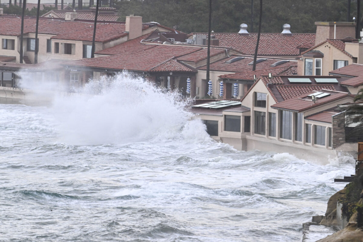
A high surf advisory was issued from 10 p.m. Sunday to 10 p.m. Monday at Orange County beaches, and until 9 p.m. Monday at Los Angeles County beaches.
Los Angeles Mayor Karen Bass is urging Angelenos to stay home on Sunday, and said the city has taken a range of preemptive measures.
The city and the Los Angeles Homeless Services Authority have increased shelter and housing voucher availability to accommodate an influx of homeless people coming in from the storm. Extra shelters were expected to open by Saturday and Sunday. Residents can also call 2-1-1 for transportation to a shelter.
Los Angeles Unified School District officials said they would be in touch with parents if any campuses should need to close.
“Los Angeles Unified teams from across the District have been planning and preparing for this inclement weather system. Schools are equipped with emergency preparedness plans should campuses experience leaks, flooding or wind damage,” the LAUSD said in a statement Saturday.
“The District is also prepared with alternate plans for impacted areas. We will be in direct contact with families if schools are affected, and the Los Angeles Unified parent hotline is available Monday through Friday from 7:30 a.m. to 5:00 p.m. at 213-443-300 for families who may have questions or need additional support.”
The coming storm was also affecting the recreational activities available to Southern California residents this weekend.
NASCAR rescheduled Sunday’s planned doubleheader at the Coliseum to Saturday evening, with admission to the NASCAR Cup Series’ Busch Light Clash and NASCAR Mexico Series’ King Taco LA Batalla en El Coliseo now free.
Six Flags Magic Mountain will be closed Sunday. Santa Anita Park canceled Sunday’s eight-race program due to the forecast, and a pair of graded stakes, the Grade III, $100,000 Las Virgenes and the Grade III, San Marcos, were rescheduled for Feb. 10.
Also, in anticipation of the storm, the Getty Center and Villa announced it would be closed Sunday and Monday.
The Surf City Marathon Half Marathon and 5K races will go on in Huntington Beach, rain or shine, according to organizers, who promised to notify participants through email and social media if there are changes in plans.
The wet weather pattern will continue into Tuesday evening, with periods of rain anticipated to continue. Drier conditions are expected by Wednesday, but a chance of showers will still linger. Snow levels could fall as low as 3,500 feet by Thursday, forecasters said.
San Diego County
In San Diego County, authorities warn of potentially dangerous flooding. A flood watch will be in effect from 4 p.m. Sunday until 10 a.m. Wednesday, which includes San Diego and the county coastal cities of Carlsbad, Vista, San Diego, Escondido, Chula Vista, El Cajon, Poway, Encinitas, Borrego Springs, Santee, Julian, Oceanside, Pine Valley, San Marcos, National City and La Mesa.
Excessive run-off could result in flooding of rivers, creeks, streams and other low-lying and flood-prone locations. Creeks and streams may rise out of their banks and flooding may occur in poor drainage and urban areas, the NWS reported.
A wind advisory will go into effect from 8 p.m. Sunday until 10 a.m. Monday, and will include the cities of Oceanside, Vista, Carlsbad, Encinitas, Chula Vista, National City and San Diego.
Gusty winds could blow around unsecured objects. Tree limbs and palm fronds could be blown down and a few power outages may result, with southeast winds from 15 to 25 mph and gusts up to 35 mph in some parts of the county, weather officials said.
A high-surf advisory will also go into effect from 10 p.m. Sunday until 10 p.m. Monday, with large, breaking waves from 6 to 8 feet and sets up to 10 feet. Surf will be highest on west-facing beaches in San Diego County, according to the NWS.
In addition, a small craft advisory from will also be in effect from 10 a.m. Sunday until 10 p.m. Monday for coastal waters from San Mateo Point to the Mexican Border and out to 30 nautical miles from San Mateo Point to the Mexican border, extending 30 to 60 nautical miles out including San Clemente Island, the NWS reported.
Forecasters said south to southeast winds will increase Sunday and Monday, with gusts from 25 to 30 knots, along with seas building from 10 to 12 feet and possibly locally up to 15 feet. Strong winds and choppy/steep seas will create hazardous boating conditions for Sunday morning through much of Monday.
