
First of 2 storms batters Southern California

Traffic is diverted because of flooding on a street Thursday, Feb. 1, 2024, in Long Beach, Calif. The first of back-to-back atmospheric rivers is drenching California. Heavy rain and gusty winds began hitting the state’s north on Wednesday before moving south along the coast and snarling the Thursday morning commute in Los Angeles. (AP Photo/Eric Thayer)
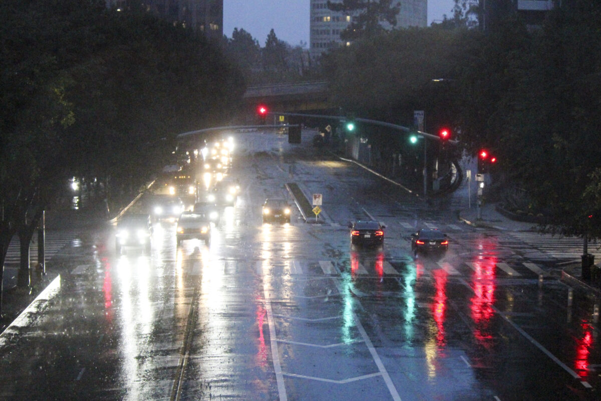
LOS ANGELES – Rain battered the Southland today as the first – and smaller – of two anticipated storms doused the region and flooded multiple streets during the morning rush hour, making the commute a nightmare for thousands of Angelenos.
By early afternoon, however, the brunt of the storm had moved out of the area. But forecasters warned that showers and isolated thunderstorms were still possible into the evening, and possibly even early Friday.
“The main frontal band has passed to the east, however, it has left behind a moderately unstable air mass which will be able to produce scattered showers and possibly even an isolated thunderstorm or two with brief periods of heavy rain,” according to a mid-afternoon statement by the National Weather Service.
“Best chances for additional precipitation will be in and near the mountains, southern L.A. County, as well as (San Luis Obispo) and northern Santa Barbara Counties. The snow level is expected to drop to around 4500 feet later (Thursday night), and while any precipitation is expected to fall as rain on the Grapevine, there’s still around a 10% chance of light snow at pass level.”
The earlier downpours, however, left their mark across the region.
Heavy rain began falling well before daybreak Thursday, making for a soggy morning commute. Flooding was reported on freeways and streets across the region.
Rainwater flooded parts of the McClure Tunnel in Santa Monica, while a Sepulveda Boulevard railroad underpass in Long Beach accumulated so much water that at least two cars were covered up to their rooftops. There were no reports of any injuries. A portion of the Long Beach (710) Freeway was also flooded, forcing motorists to slow to a crawl through the area.
Mudflows affected streets in Rancho Palos Verdes, and rocks fell onto parts of Malibu Canyon Road.
In Orange County, multiple streets in Seal Beach were inundated with water, and a stretch of Pacific Coast Highway was closed in the Huntington Beach area.
Orange County firefighters conducted a swiftwater rescue of a man trapped in a flood-control channel on Sunflower Avenue near Fairview Road, Orange County Fire Authority Capt. Thanh Nguyen said.
The man was “quickly trapped by water and started yelling for help and fortunately a passerby heard yelling and called 911,” Nguyen said.
Firefighters in the area rushed to the man and were able to get him out and take him to a local hospital to be treated for injuries that were not considered life-threatening, Nguyen said.
Slippery conditions caused cars to spin out on freeways in Los Angeles and Orange counties, resulting in various lane and road closures. The California Highway Patrol reported at least 50 spinouts and crashes on freeways and roads in the central Los Angeles area Thursday morning.
Despite the dramatic impacts of the overnight and early morning rain, forecasters said the region was actually got a bit of a break thanks to the speed at which the storm system moved through the area.
“The front is moving along at a decent clip and this will minimize the flash flooding threat — still advisory level flooding is almost certain in and around the front,” forecasters wrote in a statement early Thursday morning.
“When the front exits the eastern edge of L.A. County around noon, the steady rain will turn to showers and the amount of rain will decrease,” according to the NWS. “The front will bring about 2 inches of rain to most of the coasts and valleys. The south slopes south of Point Conception will likely see 3 to 5 inches of rain.”
As of 1:30 p.m. Thursday, 2.7 inches of rain had fallen at Leo Carrillo state beach, while 2.4 inches fell in Long Beach and roughly 1.5 inches in areas such as Beverly Hills, Santa Monica and downtown Los Angeles. A total of 2.4 inches fell at Los Angeles International Airport, 2.1 inches in Woodland Hills and 1.4 inches in Pasadena and Newhall. One location in the Santa Monica Mountains recorded 3.4 inches of rain.
A winter storm warning will be in effect until 10 p.m. Thursday in the eastern San Gabriel Mountains, including Mount Wilson, Mount Baldy, Wrightwood and the Angeles Crest Highway. As much as 18 inches of snow could fall above 7,000 feet in the area, with 6 inches possible at 6,000 feet and 3 inches at elevations as low as 4,500 feet. The snow will be accompanied by winds gusting at up to 55 mph, according to the NWS.
Motorists drive through storm conditions in downtown Los Angeles, Thursday, Feb. 1, 2024. The first of two back-to-back atmospheric rivers drenched California on Thursday, flooding roads and toppling trees while triggering statewide storm preparations and calls for people to get ready for powerful downpours, heavy snow and damaging winds. (AP Photo/John Antczak)
A previously issued winter storm warning was downgraded to a storm advisory in the western San Gabriel Mountains and the Golden State (5) and Antelope Valley (14) freeway corridors. In those areas, forecaster said light to moderate snow is anticipated above 6,000 feet, with a “dusting” of up to 2 inches at elevations as low as 4,500 feet. Winds in those areas will also gust up to 55 mph.
Thursday’s deluge, however, was only a preview of what’s to come beginning as early as Sunday, when the area will be hit by what forecasters are calling “the largest storm of the season.”
The storm is “forecast to spin down the coast and lift an atmospheric river into and across Southern California,” according to the NWS.
“While the exact timing, rates and amounts are still uncertain, it is very likely that this will be a serious two- to three-day storm system,” forecasters said.
“Over the (Sunday to Tuesday) period the early estimates call for widespread rain amounts of 2 to 4 inches for lower elevations and likely twice those amounts in the south facing mountains,” according to the NWS. “There are more than a few (forecasts) that call for much higher amounts than those.
Citizens and authorities need to be aware of the likelihood of significant hydrologic issues, including: rock and mud slides in the mountains and flooding of small streams and rivers as well as some chances for flooding of the larger rivers and streams. Significant and hazardous snowfall amounts will be possible above 6,000 feet through Monday night. Lower elevation snow down to around 4,000 feet is possible by later Tuesday into Wednesday.” (CNS)
