How computer mapping could help Biden fix polluted neighborhoods
Diagnosed with asthma at 8 years old, Karlaine Francisco grew up thinking everyone had it.
Her friends in south Stockton, California, also carried inhalers and suffered coughing and wheezing fits. “I would tell people, ‘Oh yeah, I have asthma,’” said Francisco, now a 17-year-old high school senior. “And then, my friend would be like, ‘Yeah, I have asthma too.’”

Elaine Labson, Health Equity Director for Little Manila Rising, and Omar Sanchez, a community health worker with Little Manila Rising, work on their computers before an interview at the Little Manila Center in Stockton, California, U.S., March 12, 2021. The organization is currently working to create classes and one-on-one training to help educate the those in the community suffering with asthma, how best to manage their illness. REUTERS/Brittany Hosea-Small
After California began making environmental data available through an online mapping tool, Francisco and others in her Filipino immigrant community realized their chronically under-invested neighborhood Little Manila suffered high air pollution and groundwater contamination. It also suffered some of the state’s highest poverty, unemployment and asthma rates.
California’s mapping tool is now a model for President Joe Biden’s government, as it executes a $2 trillion infrastructure plan that could channel billions into communities around the country like Little Manila.
In January, one week into his presidency, Biden ordered that 40% of clean energy investment go toward such communities. With experts realizing these areas first needed to be identified, Biden’s directives also called for the Environmental Protection Agency to upgrade its mapping tool, called EJScreen.
A $20 million bill to pay for the software and data collection was introduced a day later by Senators Ed Markey and Tammy Duckworth and Representative Cori Bush.
“We have a responsibility to taxpayers not to waste their tax dollars,” Duckworth told Reuters. “The mapping tool is critical to establish the areas where we need to do the most remediation.”
INFORMATION IS POWER

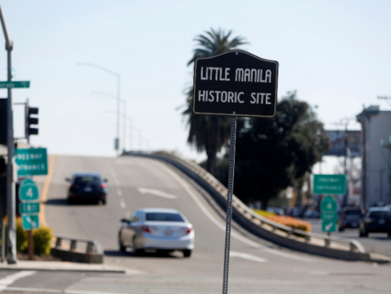
A sign marks the location of the historic site of Little Manila, of which now only two buildings still stand, in Stockton, California, U.S., March 12, 2021. REUTERS/Brittany Hosea-Small
As private companies including insurers and real estate firms launch their own satellites and deploy legions of researchers and factfinders, access to data on climate risks or environmental pollution is increasingly seen as a benefit for the wealthy or privileged.
The remedy, community leaders say, is to make such information public. Only then can people advocate for themselves.
For Little Manila, access to local demographic and environmental data through the state’s CalEnviroScreen tool helped to secure $100,000 from the state to teach asthma sufferers how to examine air filters, search for mold spores and better manage the condition.
For Francisco, access to public data gave her awareness of the industries triggering her asthma attacks. She started avoiding outdoor sports and instead practiced indoor volleyball and figure skating.
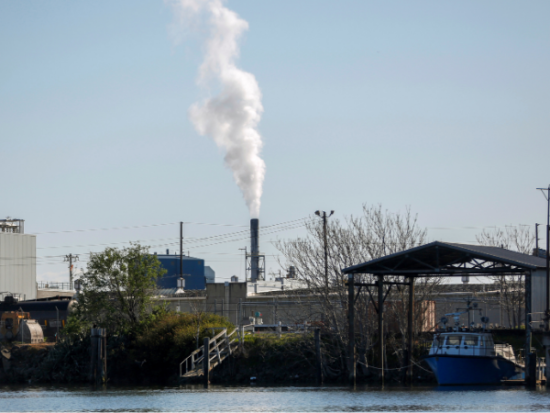
“We all grew up by the port, and we all grew up by all these factories that have all these toxic pollutants in the air,” she said. She realized why she had asthma “when I became more educated on these factors.”

Particulates are released from a smoke stack seen just beyond the Port of Stockton in Stockton, California, U.S., March 12, 2021. REUTERS/Brittany Hosea-Small
Community activists say California’s mapping tool helped tell a story about why northern Stockton has trees and green spaces while Little Manila does not, and why hospital ER visits for asthma were 2.4 times more frequent in neighborhoods like theirs than in areas with the lowest asthma visits, according to a 2020 study by the National Institutes of Health.
“We’re trying to get our community knowledgeable about these issues so they can take action,” said Dillon Delvo, a co-founder of the community group Little Manila Rising. He stood on a sunbaked sidewalk in front of the community’s recreation hall and museum harkening back to the 1920s, when the neighborhood boomed with new Filipino businesses and attracted migrant farm laborers from the surrounding San Joaquin Valley.
In the 1930s, a discriminatory lending practice referred to as “redlining” began nationwide, making minority and immigrant communities ineligible for home loans. That deprived neighborhoods like Little Manila of investment and property tax revenue, Delvo said. And when Stockton launched urban redevelopment in the 1950s and 1960s, parts of Little Manila were knocked down in 1968 to make way for the Crosstown Freeway.
“That freeway destroyed our community, and it’s still killing people today,” Delvo said, pointing to the elevated roadway perched atop concrete pillars, with trucks and trailers trundling overhead.
The data tool draws clear links between high-pollution areas and historic redlining, he said. On the map, the neighborhood jumps out in red for its pollution levels and socioeconomic indicators. Wealthier coastal spots, such as the San Francisco Bay Area, appear in green.
“A lot of history and public policy decisions have created those conditions,” said Elaine Labson, health equity director at Little Manila Rising.
One of the proposals in Biden’s infrastructure plan calls for $20 billion to be spent in neighborhoods that, like Little Manila, have been isolated or damaged by highway projects.
MAPPING CHALLENGES
Adapting the federal tool to resemble California’s will require a major overhaul.
The 2009 federal tool does not draw on public health and socioeconomic data, and does not attempt to gauge levels of need, said Matt Tejada, director of the EPA’s Office of Environmental Justice.
During the Trump administration, which proposed scrapping the EPA environmental justice budget, agency members worked on their own time to maintain the tool.
As staff at Biden’s EPA hold meetings with California officials to learn from the state’s experience, advocates hope they will focus not only on California’s successes but also on the shortcomings flagged over the years.
Some rural California areas, for example, do not report water and pesticide data. And nowhere does the state track race – data inputs advocates argue would further sharpen the tool.
Related Articles
Best GPS Devices to Buy on Amazon
How to Monetize Youtube Videos
Supporters have also urged the inclusion of data on police interactions and violent crime, because polluted areas typically receive less investment and so tend to have higher crime rates.
Police interactions “make for an unsafe environment, just as unsafe as living in a house with lead paint,” said Missouri Congresswoman Bush. “Gun violence is a result of environmental injustice, not just an indicator of it.”
One Little Manila Rising coordinator cautioned against relying too much on a data mapping tool.
“We’re being mapped to death,” Matt Holmes said. “But if we don’t give power to the people that are being injured by this history, then we’re just we’re highlighting a problem and not doing anything about it.”
(Reporting by Valerie Volcovici in Washington; Additional reporting by Nathan Frandino in Stockton, California; Editing by Katy Daigle and Lisa Shumaker)

